Product Name:HZMWD-G WIRELESS MEASUREMENT WHILE DRILLING
|
Type:
|
HZMWD-G
|
|
producer:
|
Huanding Energy Services
|
|
Description:
|
HZMWD-G Wireless Measurement While Drilling System applies mainly in the directional well, horizontal well, deviated well and branch well, for positioning during drilling and monitoring the drilling techniques. The acquired signals are stable and large. It is automatically decoding during the whole process of drilling. The tool configuration is simple, and it is easy to load and unload.
|
IntroductionCompositionSpecifications
HZMWD-GHZMWD-G Wireless Measurement While Drilling System applies mainly in the directional well, horizontal well, deviated well and branch well, for positioning during drilling and monitoring the drilling techniques. The acquired signals are stable and large. It is automatically decoding during the whole process of drilling. The tool configuration is simple, and it is easy to load and unload.
The detector in the Electronics Assembly measures the deviation, azimuth, tool face, etc. and converts these data to controlling signals. The Mud Pulser receives the controlling signals and controls the motions of drilling collar in the mud pipe. If the drilling collar is filled with mud or cleaned off, the mud pressure wave will be produced, showing higher or equal “1” or “0” to the mud pipe pressure. The mud pressure wave is detected by the Surface Pressure Transducer mounted in the mud pipe and acquired by the surface interface panel. The Notebook Computer completes the signal identification and decoding and gets the information, such as deviation, azimuth, tool face, etc. The drilling engineer analyzes the information so as to control the trajectories of directional well, horizontal well, deviated well and branch well. The measured data, at the same time, are sent to the Driller Display on the surface, so that the operator can monitor the drilling in real time. With a GR assembly, it can measure the geologic parameters in real time to realize the geologic directional function.

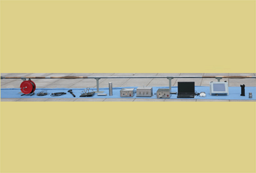
HZMWD-GThe system is composed of surface system and down tools. The surface system consists of Surface Connector BOX, Notebook Computer, Diller Display, Surface Pressure Transducer, Printer and cables. The down tool consists of Electronics Assembly, Mud Pulser, Buttery (or Down Motor), Bottom Nose and Centralizer. The down tools of HZMWD-G Wireless Measurement While Drilling System applies up-hanging mode to position the system in the Non-magnet Drill Collar. See Figure 1 and Figure 2.
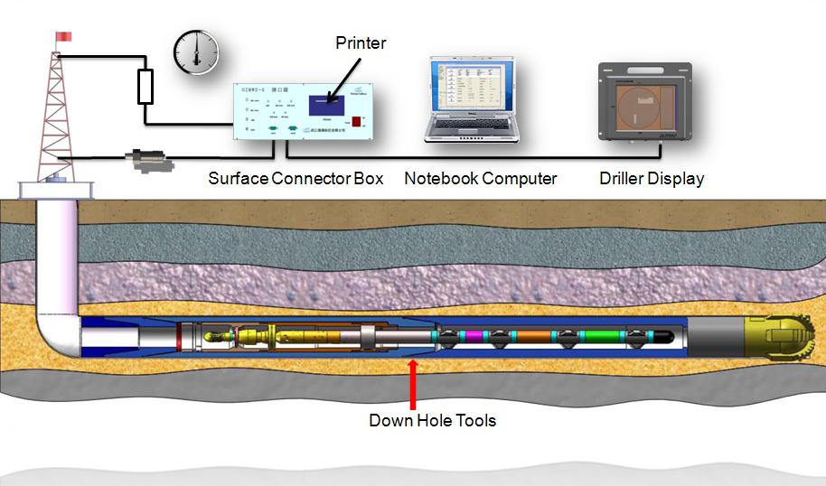
Figure 1 HZMWD-G Wireless Measurement While Drilling

Figure 2 The Down Hole Tools of HZMWD-G
Azimuth and Deviation
Azimuth: 0~360° ±1° Sampling Resolution: ±0.087°
Deviation: 0~180° ±0.1° Sampling Resolution: ±0.044°
Tool Face: 0~360° ±1.5° Sampling Resolution: ±0.087°
Tool Face Switching Degree: 2--15°
Gravity Field: ±1%
Magnet Field: ±500gamma
Geologic Parameter
Gamma: 0~250 CPS ±1CPS
MWD Temperature
Temperature: -40℃--+200℃ ±1℃ Sampling Resolution: ±0.2℃
Power Supply
Voltage: +48VDC
Working range: +42--60VDC
General Specifications
Working Temperature: -20℃~125℃
Length of Centralizer: 495mm
Vibration: 20g, 10~200Hz
Connecting Mode: single core connection
Shock: 1000g/0.5ms
Velocity: 70-1600gal/min
Max. Pressure: 15000psi
Drill Collar: 4-3/4", 6-3/4", 8", 9-1/2"
O.D.: Φ45
MUD Sand Content: ≤2%
Length of Pulser: 575mm (with Hanging Device: 993mm)
Mud Type: No request
Length of Electronics Assembly: 2185mm
Mud Viscosity: ≤50lbf/bbl
Length of Battery Housing: 2838mm
Max. Dogleg: 40°/100ft
